2004 Indian Ocean earthquake
From Wikipedia, the free encyclopedia
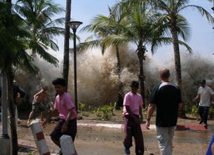
The tsunami caused by the December 26, 2004 earthquake strikes Ao Nang, Thailand.
The 2004 Indian Ocean earthquake, known by the scientific community as the Sumatra-Andaman earthquake, was an undersea earthquake that occurred at 00:58:53 UTC (07:58:53 local time) December 26, 2004, with an epicenter off the west coast of Sumatra, Indonesia. The earthquake triggered a series of devastating tsunamis that spread throughout the Indian Ocean, killing large numbers of people and inundating coastal communities across South and Southeast Asia, including parts of Indonesia, Sri Lanka, India, and Thailand. Although initial estimates have put the worldwide death toll at over 275,000 with thousands of others missing, recent analysis compiled lists a total of 229,866 persons lost, including 186,983 dead and 42,883 missing.[1] The figure excludes 400 to 600 people who are believed to have perished in Myanmar which is more than that government's official figure of only 61 dead.[2] This catastrophe is one of the deadliest disasters in modern history. The disaster is known in Asia and in the international media as the Asian Tsunami, and also called the Boxing Day Tsunami in Australia, Canada, New Zealand, and the United Kingdom as it took place on Boxing Day.
The magnitude of the earthquake was originally recorded as 9.0 on the Richter scale, but has been upgraded to between 9.1 and 9.3. At this magnitude, it is the second largest earthquake ever recorded on a seismograph. This earthquake was also reported to be the longest duration of faulting ever observed, lasting between 500 and 600 seconds, and it was large enough that it caused the entire planet to vibrate at least half an inch, or over a centimetre.[3] It also triggered earthquakes in other locations as far away as Alaska.[4]
The earthquake originated in the Indian Ocean just north of Simeulue island, off the western coast of northern Sumatra. The resulting tsunami devastated the shores of Indonesia, Sri Lanka, India, Thailand and other countries with waves up to 30 m (100 ft). It caused serious damage and deaths as far as the east coast of Africa, with the furthest recorded death due to the tsunami occurring at Port Elizabeth in South Africa, 8,000 km (5,000 mi) away from the epicenter.
The plight of the many affected people and countries prompted a widespread humanitarian response. In all, the worldwide community donated more than US$7 billion in humanitarian aid to those affected by the earthquake.
Contents
[hide]
* 1 Earthquake characteristics
o 1.1 Tectonic plates
o 1.2 Aftershocks and other earthquakes
o 1.3 Power of the earthquake
* 2 Tsunami characteristics
o 2.1 Signs and warnings
o 2.2 Retreat and rise cycle
* 3 Damage and casualties
o 3.1 Countries affected
o 3.2 Casualties in historical context
* 4 Human component in magnitude of damage
* 5 Humanitarian, economic and environmental impact
o 5.1 Economic impact
o 5.2 Environmental impact
o 5.3 Other effects
* 6 See also
* 7 Notes and references
* 8 External links
o 8.1 News collections
o 8.2 Photos and video
o 8.3 Scientific and educational
[edit]
Earthquake characteristics
Epicentre of the earthquake, just north of Simeulue Island
Enlarge
Epicentre of the earthquake, just north of Simeulue Island
The earthquake was initially reported as 9.0 on the Richter scale. In February 2005 some scientists revised the estimate of the magnitude to 9.3.[5] Although the Pacific Tsunami Warning Center has accepted these new numbers, the United States Geological Survey has so far not changed its original estimate of 9.0.
The hypocentre of the main earthquake was at 3.316°N, 95.854°E (3°19′N 95°51.24′E), approximately 160 km (100 mi) west of Sumatra, at a depth of 30 km (18.6 mi) below mean sea level (initially reported as 10 km). The earthquake itself (apart from the tsunami) was felt as far away as Bangladesh, India, Malaysia, Myanmar, Thailand, Singapore and the Maldives.
Indonesia lies between the Pacific Ring of Fire along the north-eastern islands adjacent to and including New Guinea and the Alpide belt along the south and west from Sumatra, Java, Bali, Flores, and Timor. The December 2004 earthquake actually occurred within the Alpide belt. [citation needed]
Since 1900 the only earthquakes recorded with a greater magnitude were the 1960 Great Chilean Earthquake (magnitude 9.5) and the 1964 Good Friday Earthquake in Prince William Sound (9.2). The only other recorded earthquake of magnitude 9.0 or greater was off Kamchatka, Russia, on November 4, 1952 (magnitude 9.0).[6] Each of these megathrust earthquakes also spawned tsunamis in the Pacific Ocean, but the death toll from these was significantly lower. The worst of these caused only a few thousand deaths, primarily because of the lower population density along the coasts near affected areas and the much greater distances to more populated coasts.
Other very large megathrust earthquakes occurred in 1868 (Peru, Nazca Plate and South American Plate); 1827 (Colombia, Nazca Plate and South American Plate); 1812 (Venezuela, Caribbean Plate and South American Plate) and 1700 (Cascadia Earthquake, western U.S. and Canada, Juan de Fuca Plate and North American Plate). These are all believed to have been of greater than magnitude 9, but no accurate measurements were available at the time.
[edit]
Tectonic plates
The earthquake was unusually large in geographical extent. An estimated 1,200 km (750 mi) of faultline slipped about 15 m (50 ft) along the subduction zone where the India Plate dives under the Burma Plate. The slip did not happen instantaneously but took place in two phases over a period of several minutes. Seismographic and acoustic data indicate that the first phase involved the formation of a rupture about 400 km (250 mi) long and 100 km (60 mi) wide, located 30 km (19 mi) beneath the sea bed—the longest rupture ever known to have been caused by an earthquake. The rupture proceeded at a speed of about 2.8 km/s (1.7 mi/s) or 10,000 km/h (6,300 mph), beginning off the coast of Aceh and proceeding north-westerly over a period of about 100 seconds. A pause of about another 100 seconds took place before the rupture continued northwards towards the Andaman and Nicobar Islands. However, the northern rupture occurred more slowly than in the south, at about 2.1 km/s (4,700 mph), continuing north for another five minutes to a plate boundary where the fault changes from subduction to strike-slip (the two plates push past one another in opposite directions). This reduced the speed of the water displacement and so reducing the size of the tsunami that hit the northern part of the Indian Ocean.[7]
The India Plate is part of the great Indo-Australian Plate, which underlies the Indian Ocean and Bay of Bengal, and is drifting north-east at an average of 6 cm/year (2 inches per year). The India Plate meets the Burma Plate (which is considered a portion of the great Eurasian Plate) at the Sunda Trench. At this point the India Plate subducts beneath the Burma Plate, which carries the Nicobar Islands, the Andaman Islands and northern Sumatra. The India Plate slips deeper and deeper beneath the Burma Plate until the increasing temperature and pressure drive volatiles out of the subducting plate. These volatiles rise into the crust above and trigger melt which exits the earth's crust through volcanoes in the form of a volcanic arc. The volcanic activity that results as the Indo-Australian plate subducts the Eurasian plate has created the Sunda Arc.
As well as the sideways movement between the plates, the sea bed is estimated to have risen by several metres, displacing an estimated 30 km³ (7 cu mi) of water and triggering devastating tsunami waves. The waves did not originate from a point source, as mistakenly depicted in some illustrations of their spread, but radiated outwards along the entire 1,200 km (750 mi) length of the rupture. This greatly increased the geographical area over which the waves were observed, reaching as far as Mexico, Chile and the Arctic. The raising of the sea bed significantly reduced the capacity of the Indian Ocean, producing a permanent rise in the global sea level by an estimated 0.1 mm.[8]
[edit]
Aftershocks and other earthquakes
Locations of initial earthquake and all aftershocks measuring greater than 4.0 from December 26, 2004-January 10, 2005. The initial quake is indicated by the large star in the lower right square of the grid. (Credit: USGS)
Enlarge
Locations of initial earthquake and all aftershocks measuring greater than 4.0 from December 26, 2004-January 10, 2005. The initial quake is indicated by the large star in the lower right square of the grid. (Credit: USGS)
Numerous aftershocks were reported off the Andaman Islands, the Nicobar Islands and the region of the original epicentre in the hours and days that followed. The largest aftershock of magnitude 8.7 was located off the Sumatran island of Nias.[9] A debate arose among seismologists over whether the 2005 Sumatra earthquake should be considered an aftershock of the December 2004 event or a "triggered earthquake" (an earthquake brought about by a previous earthquake),[10] as it was larger than typical aftershocks but on the same fault. Other aftershocks of up to magnitude 6.6 continued to shake the region daily for up to three or four months. As well as continuing aftershocks, the energy released by the original earthquake continued to make its presence felt well after the event. A week after the earthquake, its reverberations could still be measured, providing valuable scientific data about the Earth's interior.
The 2004 Indian Ocean earthquake came just three days after a magnitude 8.1 earthquake in an uninhabited region west of New Zealand's sub-Antarctic Auckland Islands, and north of Australia's Macquarie Island. This is unusual, since earthquakes of magnitude 8 or more occur only about once per year on average.[11] Some seismologists have speculated about a connection between these two earthquakes, saying that the former one might have been a catalyst to the Indian Ocean earthquake, as the two earthquakes happened on opposite sides of the Indo-Australian Plate. However, the U.S. Geological Survey sees no evidence of a causal relationship in this incident. Coincidentally, the earthquake struck almost exactly one year (to the hour) after a 6.6 magnitude earthquake killed an estimated 30,000 people in the city of Bam in Iran on December 26, 2003.[12]
An earthquake of magnitude 8.7 was reported shortly at 16:09:37 UTC (23:09:37 local time) on March 28, 2005, approximately at the same location (see 2005 Sumatran earthquake). It was likely a very large aftershock of the original earthquake. This earthquake had strong aftershocks of its own, including magnitude 6.0 and 6.1 earthquakes. At 8.7 it ranks as the 7th largest earthquake since 1900. A 6.7 magnitude earthquake struck on April 10, 2005, at 10:29 UTC (17:29 local time) about 120 km (75 mi) south-west of the city of Padang.[13][14]
Some scientists confirm that the December earthquake had activated Leuser Mountain, a volcano in Aceh province along the same range of peaks as Talang, while the 2005 Sumatran earthquake had sparked activity in Lake Toba, an ancient crater in Sumatra.[15] Geologists say that the eruption of Mount Talang in April 2005 is connected to the December earthquake.[16]
[edit]
Power of the earthquake
The total energy released by the 2004 Indian Ocean earthquake has been estimated as 3.35 exajoules (3.35×10¹⁸ joules). This is equivalent to over 930 terawatt hours, 0.8 gigatons of TNT, or about as much energy as is used in the United States in 11 days. However, the most reliable seismic energy release estimate, as of September 30, 2005, is 1.1×10¹⁸ joules. This corresponds to about 0.25 gigatons of TNT. The earthquake is estimated to have resulted in an oscillation of the Earth's surface of about 20–30 cm (8–12 in), equivalent to the effect of the tidal forces caused by the Sun and Moon. The shock waves of the earthquake were felt across the planet; as far away as the U.S. state of Oklahoma, where vertical movements of 3 mm (0.12 in) were recorded.[17] The entire Earth's surface is estimated to have moved vertically by up to 1 cm.
The shift of mass and the massive release of energy very slightly altered the Earth's rotation. The exact amount is yet undetermined, but theoretical models suggest the earthquake shortened the length of a day by 2.68 microseconds (2.68 µs, or about one billionth of the length of a day), due to a decrease in the oblateness of the Earth.[18] It also caused the Earth to minutely "wobble" on its axis by up to 2.5 cm (1 in) in the direction of 145° east longitude,[19] or perhaps by up to 5 or 6 cm (2.0 to 2.4 in).[20] However, because of tidal effects of the Moon, the length of a day increases at an average of 15 µs per year, so any rotational change due to the earthquake will be lost quickly. Similarly, the natural Chandler wobble of the Earth can be up to 15 m (50 ft).
More spectacularly, there was 10 m (33 ft) movement laterally and 4–5 m (13–16 ft) vertically along the fault line. Early speculation was that some of the smaller islands south-west of Sumatra, which is on the Burma Plate (the southern regions are on the Sunda Plate), may have moved south-west by up to 20 m (66 ft), and some early estimates said up to 36 m (118 ft). However, more accurate data released, more than a month following the earthquake, present a more manageable figure of 20 cm (7.9 in).[21] Since movement was vertical as well as lateral, some coastal areas may have been moved to below sea level. The Andaman and Nicobar Islands appear to have shifted south-west by around 1.25 m (4.1 ft) and to have sunk by 1 m (3.28 ft).[22]
In February 2005 the Royal Navy vessel HMS Scott surveyed the seabed around the earthquake zone, which varies in depth between 1,000 m (3,300 ft) and 5,000 m (16,500 ft) west of Sumatra. The survey, conducted using a high-resolution, multi-beam sonar system, revealed that the earthquake had made a huge impact on the topography of the seabed. Previous activity on the fault over geological periods of time had created large thrust ridges, about 1,500 m high, which collapsed in places during the earthquake to produce large landslides several kilometres across. One landslide consisted of a single block of material some 100 m (300 ft) high and 2 km (1.25 mi) long. The force of the displaced water was such that individual blocks of rock, massing millions of tons apiece, were dragged as much as 10 km (7 mi) across the seabed. An oceanic trench several kilometres wide was exposed in the earthquake zone.[23]
By a beneficial and remarkable coincidence, the TOPEX/Poseidon and Jason 1 satellites happened to pass over the tsunami as it was crossing the ocean.[24] These satellites carry radars that measure precisely the height of the water surface; anomalies of the order of 50 cm (20 in) were measured. Measurements from these satellites may prove invaluable for the understanding of the earthquake and tsunami.[25] Unlike data from tide gauges installed on shores, measurements obtained in the middle of the ocean can be used for computing the parameters of the source earthquake without having to compensate for complex effects close to the coast. Inversion of this height data may help adjust the parameters for the source earthquake.
Taken from:2004 Indian Ocean Earthquake

Nuclear Sub Crushed
Updated: 11:41, Friday January 28, 2005
The first pictures of an American nuclear submarine that crashed into an undersea mountain have been released.
The USS San Francisco was travelling at around 30 miles an hour when it ran aground 350 miles off the coast of Guam last month.
Pictures released by the US Navy show the front of the submarine completely cut off.
One sailor was killed and 23 others seriously injured.
A team of navy experts is preparing to assess the damage to determine whether the warship can be repaired and returned to sea.
Advertisement
Satellite images of the area where the submarine crashed show a wedge-shaped mountain that stretches across more than a mile of desolate expanse in the South Pacific.
Military officials told the New York Times that the mountain, which rises within 100 feet of the surface, was not on the navigation charts.
The satellite pictures suggest that the mountain is part of a larger range of undersea volcanoes and reefs.
Experts say that had the sub's active sonar system been switched on it may have been able to detect the mountain.
But US submarines usually have it switched off because when it detects anything, it makes a loud pinging noise and can give away the sub's location to potential enemies.
Taken from: Nuclear Sub Crashed into Underground Volcanic Mountain

No comments:
Post a Comment